 |
| Big and small ships landed in the beaches of Lapu-lapu City blown away by typhoon Odette |
BY JUN ENRIQUEZ
(President, MMM - Manggagawang Media ng Mindanaw)
I was motivated to deepen my understanding on the impact of climate change, a global environmental challenge to all of us and take responsibility in this earth we live. Our God Almighty said that man created by his own image will keep continue the existence of all the things on earth as He did it in just 6 days and on the seventh day He take a rest. What is known to us is that climate change is an environmental movement of weather conditions from good to worst, and I’m sure this is against the will of God destructed His creation by the evils.
Climate change is an effect caused by the excessive carbon emissions due to the continuously burning of fossil fuels, coal, deforestation, among others, produces extreme heat that will results to heatwaves, typhoons, floods, drought, hunger and dying, is now happening globally. Emissions caused by the burning fuels trapped the heat in the atmosphere since the start of the industrial era. The formation of extra heat is not evenly distributed across the globe cause burn out into extreme weather catastrophe.
.jpg)
Climate change is changing the weather condition. Just recently, UK encountered the highest temperature for the first time at more than 40C on July 19 and other countries in the North. In an area of high pressure, hot air is pushed down and trapped in place, causing temperatures to rise over an entire continent.
The extreme heat seen during the most recent heatwave is ten times more likely now because of climate change, and this could worsen the situation. Climate scientist says concerning in the northern part of the globe, "In a few decades this might actually be a quite a cool summer,” heatwaves are not just hotter, they are also lasts longer and warm spells over more than doubled in length in the past 50 years.
Heatwaves can be made longer and more intense by another weather phenomenon - a heat dome. How heat domes forms? It is a mass of warm air builds up in still and dry summer conditions; High pressure in the atmosphere pushes the warm air down; the air is compressed and gets even hotter.
 |
| Heat Dome Analysis (Photo credits: BBC) |
The cycle of extreme and long-lasting heat caused by climate change draws more and more moisture out of the ground and vegetation. These tinder-dry conditions provide fuel for fires, which can spread at an incredible speed turned into super typhoons. More extreme rainfall events - In the usual weather cycle, hot weather creates moisture and water vapour in the air and clouds in the sky, which turns into droplets to create rain and dangerous flashfloods.

How high temperature cause extreme rainfall? More heat from the sun causes greater evaporation; More moisture forms clouds; Results Heavier rain. The warmer it becomes, however, the more vapour there is in the atmosphere. This results in more droplets and heavier rainfall, sometimes in a shorter space of time and over a smaller area.
Already this year, floods have hit Spain and also parts of eastern Australia. In a period of just six days Brisbane saw almost 80% of its annual rainfall, while Sydney recorded more than its average annual rainfall in little over three months.
In the Philippines, typhoons occur any time of the year within the months of June to September being most active. The month of August is the most active individual month and May the least active month. Approximately 20 tropical cyclones enter the Philippine area of responsibility yearly, an area which incorporates parts of the pacific ocean, the south china sea and the Philippine archipelago. In each year, 10 cyclones expected to be typhoons, with five potentially cause destructions.
.jpg) |
| PAGASA Press briefing |
The deadliest overall tropical cyclone that have been hit the Philippines was the Haiphong typhoon, estimated to have killed up to 20,000 people as it passed in the country in September 1881. In modern meteorological records, the deadliest storm was typhoon Yolanda (International name Haiyan), became the strongest tropical cyclone with wind blows at a speed of 315 km per hour, as it crossed in the Visayas on November 7-8, 2013 as it killed to at least 6,352 people. Typhoon Sendong with international name “Washi” hit Iligan City with heavy flashfloods struck at the midnight on Dec 16, 2011, with weather advisory at Signal no. 2 prior to landfall, killing at least 1,200 people and missing to at least thousand others. Of the same situation, typhoon Sendong also recorded at least a thousand people died as it hit Cagayan de Oro City.
 |
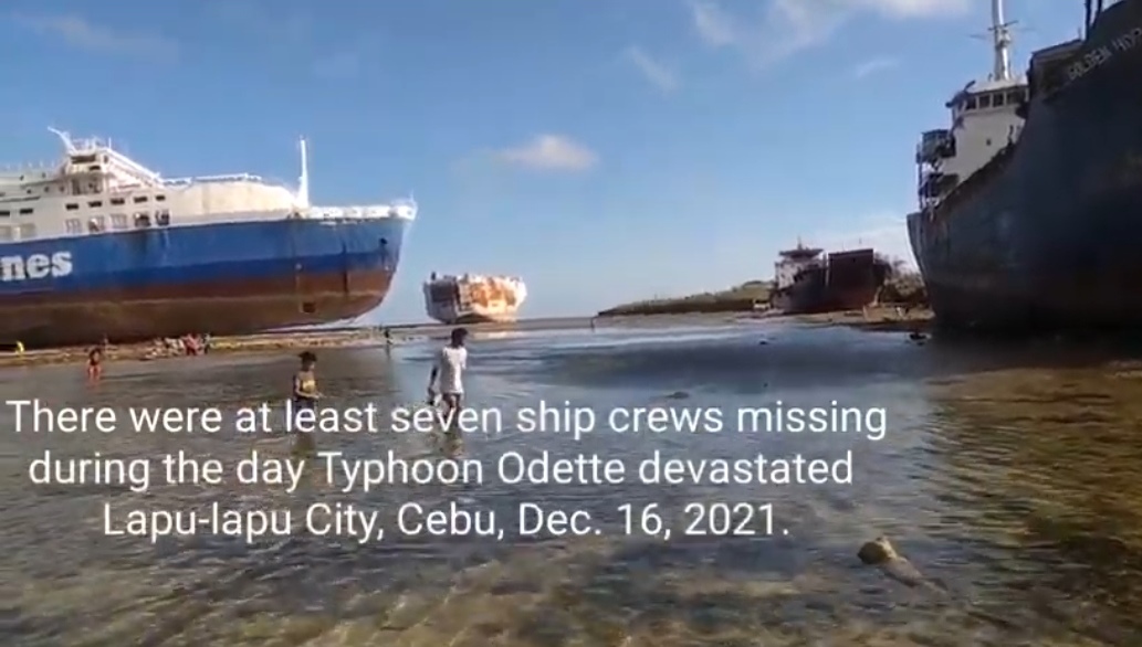
| Typhoon Odette flattened residential houses in Lapu-lapu City |
Another deadly Typhoon was the super typhoon “Odette” with international name “Rai” struck on the early evening of December 16, 2021, hitting central Visayas and eastern part of Mindanao, particular in Surigao Peninsula, killing at least 410 people. The super typhoon Odette had a wind speed at 260 km per hour. These are the only few of super typhoons recorded in the country as an effect of climate change. Tropical cyclones usually account for at least 30 percent of the annual rainfall in northern Philippines and less than 10 percent of the annual rainfall in the south.
 |
| Electric Post blown by "Odette" blocked City road in Cebu city |
At this point, people should learn how to protect themselves from risks on the effects of climate change. Our government should take drastic moves to strictly implement laws and policies to reduce carbon emissions, for the protection of the environment and its people.


No comments:
Post a Comment